OsmAnd+ — Maps & GPS Offline
4.8.1
OsmAnd+ (OSM Automated Navigation Directions) is a map and navigation application with access to the free, worldwide, and high-quality OpenStreetMap (OSM) data. Enjoy voice and optical navigation, viewing POIs (points of interest), creating and managing GPX tracks, using contour lines visualization and altitude info, a choice between driving, cycling, pedestrian modes, OSM editing and much more.
Size
329.1 MBVersion
4.8.1
329.1 MBVersion
4.8.1
Report this app
Description
OsmAnd+ Overview
OsmAnd+ (OSM Automated Navigation Directions) is a map and navigation application with access to the free, worldwide, and high-quality OpenStreetMap (OSM) data. Enjoy voice and optical navigation, viewing POIs (points of interest), creating and managing GPX tracks, using contour lines visualization and altitude info, a choice between driving, cycling, pedestrian modes, OSM editing and much more.
Features of OsmAnd+
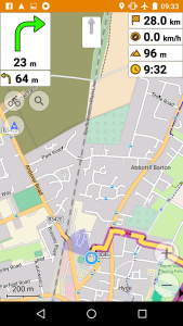
- Navigation
- Works online (fast) or offline (no roaming charges when you are abroad)
- Turn-by-turn voice guidance (recorded and synthesized voices)
- Optional lane guidance, street name display, and estimated time of arrival
- Supports intermediate points on your itinerary
- Automatic re-routing whenever you deviate from the route
- Search for places by address, by type (e.g.: restaurant, hotel, gas station, museum), or by geographical coordinates
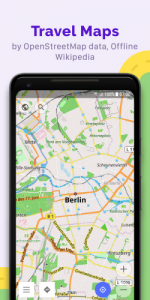
- Map viewing
- Display your position and orientation
- Optionally align the picture according to compass or your direction of motion
- Save your most important places as Favorites
- Display POIs (point of interests) around you
- Display specialized online tiles, satellite view (from Bing), different overlays like touring/navigation GPX tracks and additional layers with customizable transparency
- Optionally display place names in English, local, or phonetic spelling
- Use OSM and Wikipedia data
- High-quality information from the best collaborative projects of the world
- OSM data available per country or region
- Wikipedia POIs, great for sightseeing
- Unlimited free downloads, directly from the app
- Compact offline vector maps updated at least once a month
- Safety features
- Optional automated day/night view switching
- Optional speed limit display, with reminder if you exceed it
- Optional speed-dependent zooming
- Share your location so that your friends can find you
- Bicycle and pedestrian features
- Viewing foot, hiking, and bike paths, great for outdoor activities
- Special routing and display modes for bike and pedestrian
- Optional public transport stops (bus, tram, train) including line names
- Optional trip recording to local GPX file or online service
- Optional speed and altitude display
- Display of contour lines and hill-shading (via additional plugin)
- Directly contribute to OSM
- Report data bugs
- Upload GPX tracks to OSM directly from the app
- Add POIs and directly upload them to OSM (or later if offline)
- Optional trip recording also in background mode (while device is in sleep mode)
System Requirements for OsmAnd+
RAM: 2 GB
Operating System: Android 6.0+
Space Required: 400 MB
What's new
- Fix crashes (minor update)
Images